

| Publication Summary
|
| Issue ID: | OF2004-09 |
| Title: | Helicopter-borne Gamma Ray Spectrometric and Magnetic Total Field Geophysical Survey, Horsefly Area, British Columbia |
| Author(s): | Shives, R.B.K., Carson, J.M., Ford, K.L., Holman, P.B., Cathro, M. |
| Series Name: | Open File |
| Publication Year: | 2004 |
| Other Citation Details: | Also published as GSC Open File 4617 |
| NTS Map Sheet(s): | Parts of 093A/03,05,06,11 |
| Place Keyword(s): | British Columbia, Horsefly |
| Lat/Long (NSWE): | 52.5799, 52.219, -121.8199, -121.133 |
| Theme Keyword(s): | gamma-ray spectrometric, magnetic total field, geophysics |
| Download(s): | PDF, ZIP (View Zip Contents) |
Abstract: 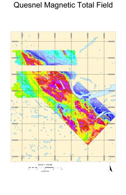 | In 2003 the Geological Survey of Canada conducted a multisensor (gamma-ray spectrometric, magnetic total field) helicopter-borne geophysical survey in the Horsefly area, British Columbia, Canada. Flight lines were oriented NE-SW, spaced at 500 m intervals. The survey was flown under contract, by Fugro Airborne Surveys. Results are combined with the previously flown 1993 Mount Polley Survey (93A/12). The survey was funded by the British Columbia and Yukon Chamber of Mines� �Rocks to Riches� Program. |


