

| Publication Summary
|
| Issue ID: | OF2004-10 |
| Title: | Helicopter-borne Gamma Ray Spectrometric and Magnetic Total Field Geophysical Survey, Mount Polley Mine Area, British Columbia |
| Author(s): | Shives, R.B.K., Carson, J.M., Ford, K.L., Holman, P.B., Cathro, M. |
| Series Name: | Open File |
| Publication Year: | 2004 |
| Other Citation Details: | GSC Open File 4619, originally published as GSC Open File 2802 |
| NTS Map Sheet(s): | Part of 093A/12 |
| Place Keyword(s): | British Columbia, Mount Polley |
| Lat/Long (NSWE): | 52.60969, 52.49797, -121.743, -121.563696 |
| Theme Keyword(s): | gamma-ray spectrometric, magnetic total field, geophysics |
| Download(s): | PDF, ZIP (View Zip Contents) |
Abstract: 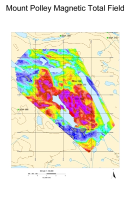 | In 2003 Imperial Metals Corporation conducted a multisensor (gamma-ray spectrometric, magnetic total field) helicopter-borne geophysical survey over the Mount Polley Mine area, British Columbia, Canada. Flight lines were oriented east-west, spaced at 100 m intervals. The survey was flown under contract, by Fugro Airborne Surveys. The survey was funded by Imperial Metals Corporation and the British Columbia & Yukon Chamber of Mines "Rocks to Riches" Program. |


