

| Publication Summary
|
| Issue ID: | OF2011-05 |
| Title: | Surficial geology, Adsett Creek (NTS 94J/SE), British Columbia |
| Author(s): | Trommelen, M., Levson, V.M. |
| Series Name: | Open File |
| Publication Year: | 2011 |
| Other Citation Details: | Also published as Geological Survey of Canada Open File 6832 |
| Larger Work Citation: | Also published as Geological Survey of Canada Open File 6832 |
| Scale: | 1:100000 |
| NTS Map Sheet(s): | 094J/01; 094J/02; 094J/07; 094J/08 |
| Place Keyword(s): | British Columbia, Northeast, Fort Nelson, Adsett Creek |
| Lat/Long (NSWE): | 58.5, 58, -123, -122 |
| Theme Keyword(s): | Surficial Geology Map, Quaternary, Aggregate, Surficial Geology |
| Download(s): | |
Abstract: 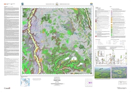 | The Adsett Creek map area (NTS 094J/SE) is situated in northeastern British Columbia, south of Fort Nelson. Most of the study area is located within the Fort Nelson Lowland physiographic region (Holland 1976), a generally flat, low-lying area 450-600 m above sea level (asl). Flat-topped mesas in the southern map area are located within the Alberta Plateau physiographic region (Holland 1976), rising 60-90 m above the lowland to an elevation 910 m asl. The Prophet River flows north through the study area, and eventually joins the Muskwa River. The area is blanketed by Boreal forest (white and black spruce, aspen, lodgepole pine) and underlain by soils with high clay content that result in abundant poorly drained bog and fen areas. The main economic activities in the map area include oil and gas exploitation and forestry. Operating funds for the 2010 mapping program were provided by the BC Geological Survey, a private-public partnership agreement with Kutcho Copper Corporation, the Geological Survey of Canada (EDGES component of the GEM program) and a partnership agreement with the University of Victoria. |


