

| Publication Summary
|
| Issue ID: | OF2016-04 |
| Title: | Ice-flow indicator compilation, British Columba and Yukon |
| Author(s): | Arnold, H., Ferbey, T., Hickin, A.S. |
| Series Name: | Open File |
| Publication Year: | 2016 |
| Other Citation Details: | Also published as Geological Survey of Canada Open File 8083 |
| NTS Map Sheet(s): | 082;083;092;093;094;095;102;103;104;105;114 |
| Place Keyword(s): | British Columbia, Cordilleran ice sheet, Canadian Sector, Yukon |
| Lat/Long (NSWE): | 65, 48, -124, -114 |
| Theme Keyword(s): | Ice-flow indicator, drift prospecting, Late Pleistocene, directions, digital stereo air photos |
| Download(s): | PDF, ZIP (View Zip Contents) |
Abstract: 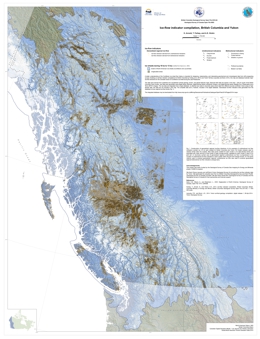 | A better understanding of the Cordilleran ice sheet flow history is important for designing, implementing, and interpreting geochemical and mineralogical data from drift prospecting surveys. Building on ice-flow indicator compilations for British Columbia by Ferbey et al. (2013) and Yukon Territory (Lipovsky and Bond, 2014), this map and database illustrate major ice-flow directions for the Canadian sector of Cordilleran ice sheet during the Late Pleistocene. The data were derived from published and unpublished surficial geology, terrain, and glacial feature maps. Because field data are sparse in the area ~ 300 km south of the British Columbia -Yukon border, new data were generated using digital stereo airphotos, digital derived-stereo orthophoto mosaics, and digital derived-stereo Satellite Pour l'Observation de la Terre (SPOT ) imagery. The raw data are integrated into a single database; no attempt was made to reconcile cases where data from different sources conflict. |


