ASTER Download A number of download products are available for each ASTER image displayed on the MapPlace. Some of these files can be used with commonly available software found on most computers, but many of the products provided here require specialized software. Many of the files are very large. They have been compressed with PKZip where appropriate. The approximate download and uncompressed file sizes are provided for each product. The Image Analysis Toolbox enhancements, ASTER images and these downloads were added through funding from a Geoscience BC project.
Original ASTER data
ASTER image data in the original format as received from the USGS. The HDF format can be read by most common GIS and image analysis software but cannot be easily displayed in common image display programs such as Photo Shop and Paint Shop. The Zipped file is about 100 MB in size.
ASTER DEM
As part of the orthorectification process a detailed digital elevation model has been generated. The elevation values are relative, not absolute, but could be adjusted to absolute values if good ground control values are available. The files are available in two formats; GeoTiff and USGS DEM. The data spacing within the elevation grid is 30 metres and elevation values are given in metres. The grids are in UTM NAD83 projection.
Virtual Reality File
A high resolution virtual reality file is available for download. These files are typically about 200 MB in size and require a virtual reality viewer capable of reading *.WRL file formats.
Stereo Pair Images
Stereo Pair images of the ASTER scene are available in JPEG format. The images have 15 metre resolutions and are in black and white. The "left" image has been orthorectified so any work requiring spatial accuracy should be performed on this image. The image is in UTM Projection. Subsets of the full image can be produced and printed to provide smaller scale viewing.
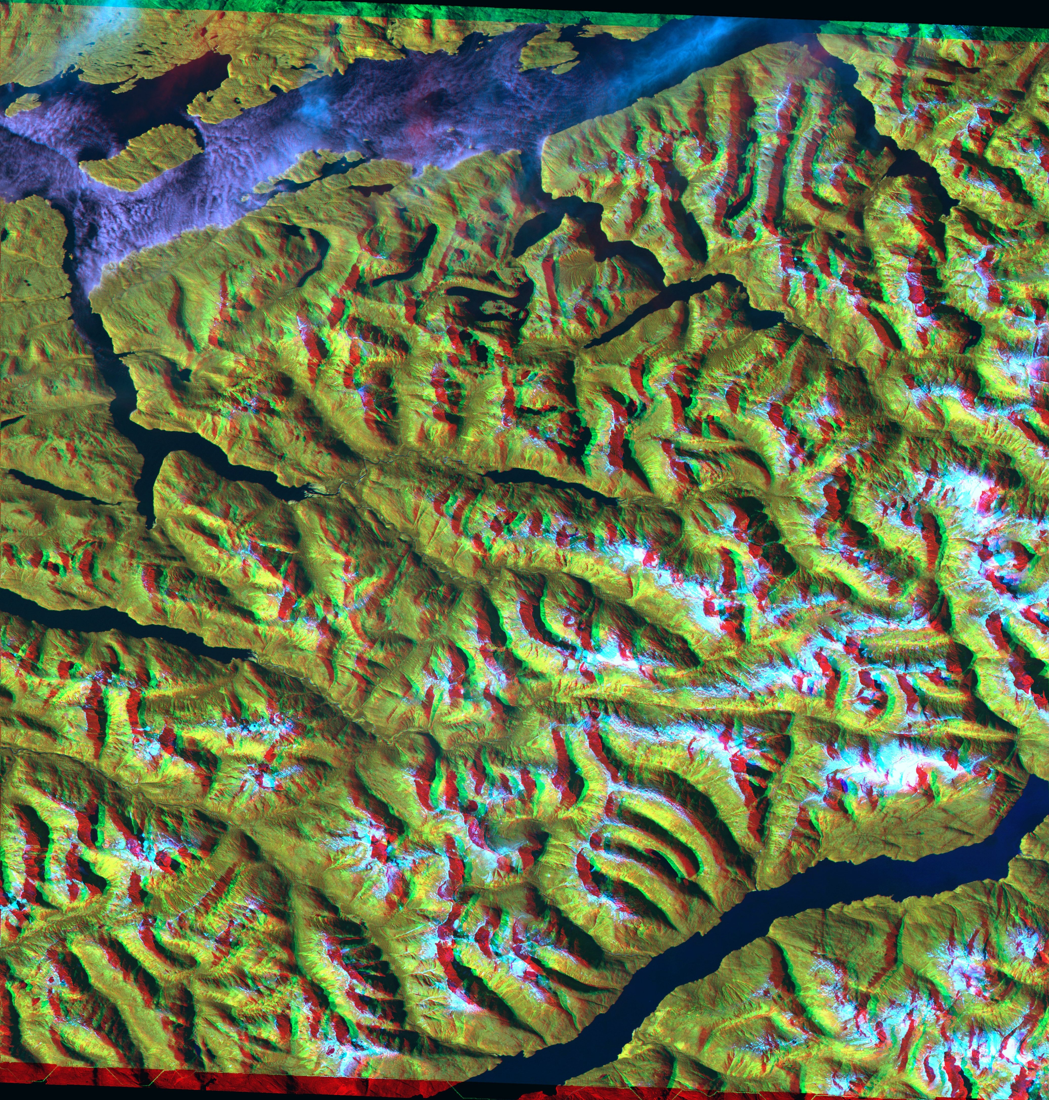
Anaglyph Image
An anaglyph image in JPEG format is available for download. The image requires red/cyan anaglyph glasses for viewing in 3D and is in colour. The image has been orthorectified so can be used for purposes requiring spatial accuracy. It is in UTM projection.
Alteration-Mineral Images
Four alteration-mineral images are available in PNG format with PGW world files. These images were produced using standard combinations of the ASTER bands.
The four images can be used to map the relative abundance of siliceous rocks, iron oxides, sericite and illite, and alunite and/or kaolinite.
See the Fieldwork 2005 article for processing information on these images.
The images are in UTM projection. As the colour scaling is unique to each image, the colours should not be compared between images.
ASTER KML File
ASTER Image files can be displayed through applications like Google Earth. These applications provide a significant advancement in viewing geospatial information. Each display includes:
Ministry of Energy, Mines and Petroleum Resources
Exploration Assistant Image ID
Download Size: 30 - 73 MB
Uncompressed Size: 118 MB
Download Size: GEOTiff 1-6 MB, USGS DEM 1-7 MB
Uncompressed Size: GEOTiff 13-17 MB, USGS DEM 40-52 MB
Download Size: 60 - 70 MB
Uncompressed Size: 200 - 300 MB
Download Size: 8 - 27 MB
Uncompressed Size: 8 - 27 MB
Download Size: 5 MB
Download Size: 1-22 MB
BC Geological Survey
Image Analysis Toolbox (IAT)